
| 
| |
|
|
This page contains photographs of British Columbia's Highway 23 (Big Bend Highway), arranged by location from Revelstoke
northerly to Mica Dam. All photographs displayed on this page were taken by the Webmaster (Cameron Bevers). To view photos of other British Columbia Highways,
please select a highway number listed on the British Columbia Photograph Index Page. Click on any
thumbnail to see a larger image!
Please note that all photographs displayed on this website are protected by copyright. These photographs must not be
reproduced, published, electronically stored or copied, distributed, or posted onto other websites without my written permission. If you want to use photos from this
website, please email me first for permission. Thank-you!
|
|---|
|
Page 2: BC Highway 23 (Big Bend Highway) Photographs: Revelstoke to Mica Dam

Left - Entering Revelstoke on the eastbound Trans-Canada Highway (Hwy 1 & Hwy 23). The City Centre lies a short distance south of the highway across the
bridge. See an Enlarged Photo Here. (Photograph taken on June 6, 2015 - © Cameron Bevers) Right - Distance guide sign on westbound Hwy 1 & Hwy 23 departing Revelstoke. See an Enlarged Photo Here. (Photograph taken on June 6, 2015 - © Cameron Bevers) 

Left - Plaque commemorating the completion of the Columbia River Bridge in 1961. This new two-lane structure bypassed a narrow one-lane steel through truss
structure on the original route of the Trans-Canada Highway (Wilson Street), which crosses the Columbia River a short distance downstream. See an
Enlarged Photo Here. (Photograph taken on June 6, 2015 - © Cameron Bevers) Right - Facing east along Hwy 1 & Hwy 23 at the Columbia River Bridge in Revelstoke. See an Enlarged Photo Here. (Photograph taken on June 6, 2015 - © Cameron Bevers) 

Left - View of the Columbia River Bridge and Mount Revelstoke on Hwy 1 & Hwy 23. See an
Enlarged Photo Here. (Photograph taken on June 6, 2015 - © Cameron Bevers) Right - At the western end of the Columbia River Bridge, two small observation points were built on both the north and south sides of Hwy 1 & Hwy 23. The bridge can be easily viewed from the eastern side from the Woodenhead Roadside Park. See an Enlarged Photo Here. (Photograph taken on June 6, 2015 - © Cameron Bevers) 

Left - Bridge manufacturer's plaque on the Columbia River Bridge on Hwy 1 & Hwy 23 in Revelstoke. See an
Enlarged Photo Here. (Photograph taken on June 6, 2015 - © Cameron Bevers) Right - A transport truck crosses the Columbia River Bridge on Hwy 1 & Hwy 23 in Revelstoke. This structure consists of one main suspension span and several approach spans. See an Enlarged Photo Here. (Photograph taken on June 6, 2015 - © Cameron Bevers) 

Left - Columbia River Bridge on Hwy 1 & Hwy 23 in Revelstoke, facing west. See an
Enlarged Photo Here. (Photograph taken on June 6, 2015 - © Cameron Bevers) Right - Eastern approach to the Columbia River Bridge in Revelstoke. This "double-rail" steel handrail system seen here was also used extensively in my home province of Ontario. It is quite evident that the Department of Highways of Ontario (DHO) and British Columbia's Department of Highways shared many of their bridge design techniques with one another during the 1950s and 1960s, as both jurisdictions used very similar standards. See an Enlarged Photo Here. (Photograph taken on June 6, 2015 - © Cameron Bevers) 

Left - "Woodenhead" carving on display beside Hwy 1 & Hwy 23 in Revelstoke. This curious wood carving dates from the 1930s, when the Big Bend Highway was
being built north of Revelstoke. The carving was created from the stump of a tree which was felled to make way for the Big Bend Highway. When it was first created, a
large sign was placed adjacent to Woodenhead, warning motorists "not to be a Woodenhead" and to drive safely on the narrow and winding Big Bend Highway. Originally,
the carving was located near Mile 80 on the Big Bend Highway, just south of the present-day Mica Creek townsite. Woodenhead was relocated to Revelstoke after the
Trans-Canada Highway was completed through Rogers Pass in 1962, which made the Big Bend Highway a redundant link in the provincial highway system. See an
Enlarged Photo Here. (Photograph taken on June 6, 2015 - © Cameron Bevers) Right - Interpretive panel describing the origins of the "Woodenhead" carving. It was created by Peter Fuoco of Revelstoke, who was one of the builders on the Big Bend Highway project. See an Enlarged Photo Here. (Photograph taken on June 6, 2015 - © Cameron Bevers) 

Left - Close-up of the Woodenhead carving in Revelstoke. The size of Woodenhead gives viewers some insight as to the diameter of the trees which were present
along the Big Bend Highway's route, as the carving was created entirely from a single tree trunk. This bizarre but colourful piece of early British Columbia
transportation history is located in a small roadside park beside the Columbia River Bridge on Hwy 1 & Hwy 23 in Revelstoke. See an
Enlarged Photo Here. (Photograph taken on June 6, 2015 - © Cameron Bevers) Right - Dual Hwy 1 & Hwy 23 route markers near the Columbia River Bridge in Revelstoke. See an Enlarged Photo Here. (Photograph taken on June 6, 2015 - © Cameron Bevers) 

Left - Overhead guide sign on eastbound Hwy 1 & Hwy 23 in Revelstoke approaching Victoria Road. Hwy 23 is not marked on the sign, as it is a fairly
lightly-travelled highway which reaches a dead-end at the Mica Dam. The vast majority of the traffic continues straight through Revelstoke via Hwy 1 to Golden. See an
Enlarged Photo Here. (Photograph taken on June 6, 2015 - © Cameron Bevers) Right - Facing east along Hwy 1 & Hwy 23 from the Columbia River Bridge in Revelstoke. See an Enlarged Photo Here. (Photograph taken on June 6, 2015 - © Cameron Bevers) 

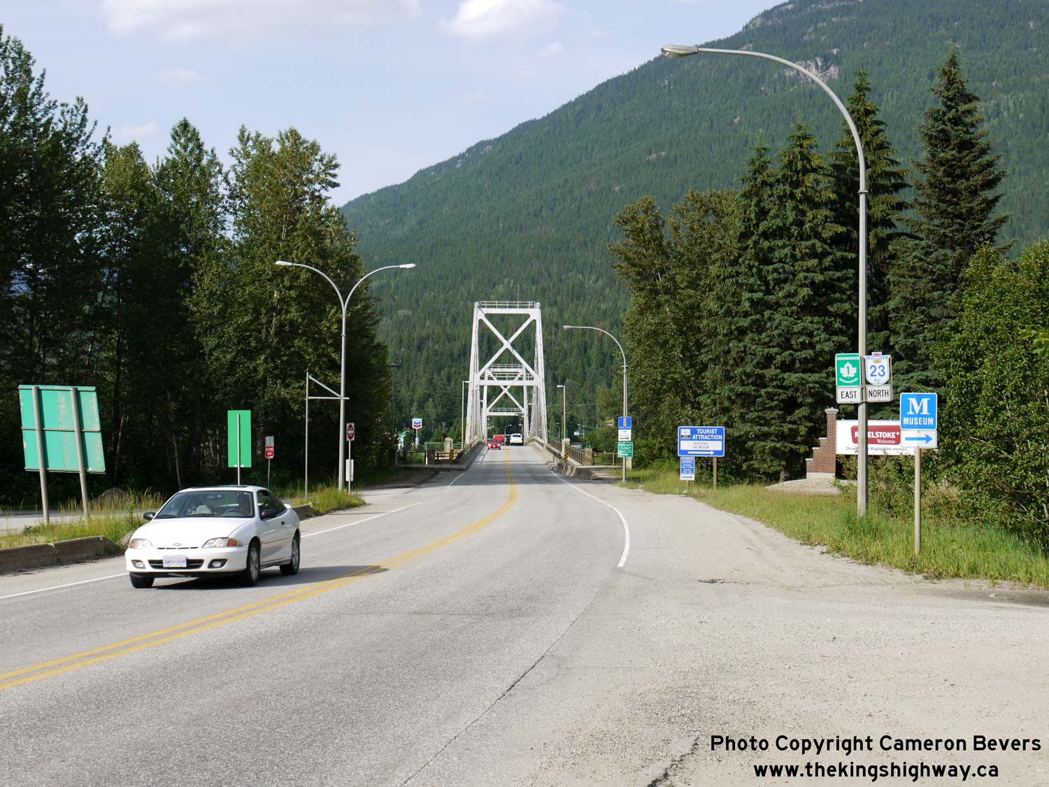
Left - Facing east along Hwy 1 & Hwy 23 in Revelstoke. At the traffic signals, Hwy 23 turns left and heads north to Mica Creek as the Big Bend Highway.
Mica Creek is the only settlement on the Big Bend Highway. Hwy 23 comes to a dead-end at the Mica Dam, located about 150 km north of Revelstoke. See an
Enlarged Photo Here. (Photograph taken on June 6, 2015 - © Cameron Bevers) Right - Facing west along Hwy 1 & Hwy 23 approaching Victoria Road in Revelstoke. Victoria Road is the main entrance to the Revelstoke City Centre. See an Enlarged Photo Here. (Photograph taken on June 6, 2015 - © Cameron Bevers) 

Left - Approaching the Hwy 23 North Junction on the westbound Trans-Canada Highway (Hwy 1) in Revelstoke. There are actually two Hwy 23 Junctions along Hwy 1
in Revelstoke. Hwy 23 North to Mica Creek intersects with Hwy 1 near Downtown Revelstoke, while Hwy 23 South to Nakusp intersects with Hwy 1 just west of the Columbia
River Bridge. See an Enlarged Photo Here. (Photograph taken on June 6, 2015 - © Cameron Bevers) Right - Facing north along Hwy 23 (Big Bend Highway) from the Hwy 1 Junction in Revelstoke. With white-capped mountain peaks in the distance, the Frontier Motel located at the Hwy 1 & Hwy 23 North Junction looks right at home! See an Enlarged Photo Here. (Photograph taken on June 6, 2015 - © Cameron Bevers) 

Left - Facing south along Hwy 23 (Big Bend Highway) towards the Trans-Canada Highway (Hwy 1) Junction in Revelstoke. Prior to the completion of the current
Trans-Canada Highway through Rogers Pass east of Revelstoke in 1962, the Big Bend Highway (Hwy 23 North) served as a highway connection between Revelstoke and Golden.
The Big Bend Highway was a seasonal road along the Columbia River which was completed and officially opened to traffic on June 29, 1940. Once the Big Bend Highway was
bypassed by the new highway link through Rogers Pass, many sections of the Big Bend Highway were flooded during the subsequent construction of hydro-electric dams
along the Columbia River in the 1970s and early 1980s. See an Enlarged Photo Here. (Photograph taken on June 6, 2015 - © Cameron Bevers) Right - Approaching the Hwy 1 Junction on the southbound Big Bend Highway (Hwy 23) in Revelstoke. It appears that this highway junction was relocated at some point. Hwy 23 now curves sharply to the left as it approaches the traffic signals on the Trans-Canada Highway (Hwy 1). See an Enlarged Photo Here. (Photograph taken on June 6, 2015 - © Cameron Bevers) |
|---|
Links to Adjacent BC Highway Photograph Pages:
Back to BC Highway 12 Photos /
British Columbia Highways Photo Index /
On to BC Highway 24 Photos
Ontario Highway History - Home / Vacation Highway Photos - Home Website contents, photos & text © 2002-2026, Cameron
Bevers (Webmaster) - All Rights Reserved / Contact Me
|
|---|